KGZ08 Key Biodiversity Area Talas river

KGZ08 Talas River
Key Biodiversity Area Talas river
Area: 2 000 hectares.
KBA Category: B1
Availability of DCA: (yes)
Location: Talas Region.
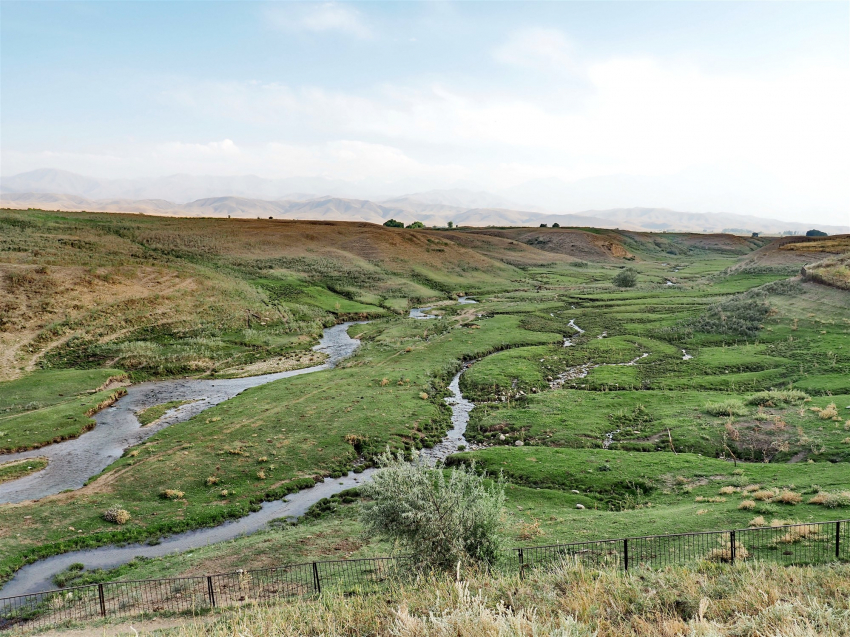
Talas is a transboundary river. Starting in the mountains of Kyrgyzstan, it ends in the sands on Kazakhstan territory. River length is 661 kilometers, catchment area is 52 700 square kilometers. Three million people living in the river basin in two neighboring countries depend on it - agriculture is actively carried out here.
River food is glacial and snow. It is formed from the conflux of the Karakol and Uch-Koshoy rivers, originating in the Talas Ala-Too glaciers in Kyrgyzstan. On its way, the Talas River receives many tributaries, of which the most full-flowing are: the Urmaral, the Kara-Buura, the Kumushtak, the Kalba and the Besh-Tash rivers.
Right bank of the Talas River is narrower than the left bank. The river forces against the right side, washing away dark rocky ridges of the Echkili Too range, almost devoid of vegetation.
A beautiful floodplain forest stretches for many kilometers along the river’s banks, it performs water protection and water regulation functions.
Elm (Ulmus, Ulmaceae) and poplar forests grow along the Talas River banks in the floodplain, which is a habitat for many species of animals and plants.
Species composition of floodplain forests depends on adaptability to environmental conditions. Shrub vegetation usually grows in the form of intemissive narrow forest strips, often forming riparian (tugai) woodlands of black poplar (Populus nigra) and Asiatic poplar (Populus diversifolia), white willow (Salix alba), gray willow (Salix cinerea), oleaster (Eleagnus angustifolia), tamarix (Tamarix laxa) and sea buckthorn (Hippophae rhamnoides).
Floodplain forests are also a habitat for water and wader birds. For example, we can meet flocks of gulls, gannets, herons near Kirov reservoir; they stay here for wintering. There are many pheasants in floodplain forests and shrubs. 
Environmetal problems:
In general, in floodplain forests of Talas, as well as throughout Kyrgyzstan, mixed stands predominate, often turned into low and medium stocked planted vegetations due to anthropogenic impact. This is mainly caused by their intensive unauthorized felling and due to difficult financial situation of population especially in recent years. Intensive grazing is also carried out here.
There are gold deposits right at the very head of the Talas River: Dzherui on the Uch-Koshoy River and Andash and Aktash on the right bank of the Karakol River. And downstream, there are also ore and alluvial gold deposits almost at the junction of each tributary of the Talas River.
Currently, gold mining in Talas leads to destruction of entire ecosystem of the river taken as a whole and Talas valley: this is an avulsion, pastures degradation, and flora and fauna destruction in the region. In addition, all this is happening for the sake of mining a small amount of gold, which is indicated in licenses.
For example, the license for the Urmaral deposit states that there are 11 kg of gold. Moreover, a plot of more than 600 hectares of beautiful floodplain forests under it is given for this purpose. It turns out that if this site was purchased at an auction for 7 thousand US dollars, then one hectare of ecologically clean riverbeds, forests and pastures is “sold” for less than 10 dollars. This is a manifestation of extravagance. This type of management is unacceptable.
Thus, the public should be actively involved in monitoring activities of gold mining companies, which should work in compliance with all environmental, sanitary standards and an equitable distribution of profits. 
Transboundary water use:
Having a glacial and snow feeding, the Talas River flows for 661 km to Muyunkum sands, where it is lost. On the plain, its waters are drawn for irrigation and for many years have been the object of interests of neighboring states - Kyrgyzstan and Kazakhstan.
There are Talas, Temirbek, Zhyembet and Uyuk waterworks facilities on the river. There is also Kirov reservoir on the river. Flood time occurs from late April to early September. Average water flow in the upper reaches (555 km from the mouth) is 15.7 m³/sec, above Taraz town (444 km from the head) is 27.4 m³/sec.
In 2000, the countries signed an agreement on the use of interstate water facilities on the Talas River. This document obliges Kazakhstan to reimburse part of costs to Kyrgyzstan for maintenance and repair of canals, dams and reservoirs owned by the Kyrgyz Republic, but providing water supply to both republics. The agreement does not stipulate quantitative aspect of dividing the river flow, so both parties adhere to the principle of equal distribution of resources, adopted back in Soviet times.
Kazakhstan periodically complains that it does not receive agreed amount of water. However, Kyrgyzstan itself suffers from water shortage.
Chu-Talas Water Commission is a unique example of joint operation of hydraulic structures, joint solution of water apportioning problems, joint financing of such processes, and in proportion to the share of water that each country receives. It is also a unique example of international cooperation on adaptation to climate change in transboundary river basins.
However, water recession due to accelerating climate change and human activities is a cause for concern about relations of neighboring countries. Voltage can rise in proportion to how water flow decreases. Will countries manage to change something? 
Species under threat of global extinction and other priority species in KBA: Lindberg’s dace (Leuciscus lindbergi), Turdakov’s Char (Dzihunia turdakovi), Terek stone loach (Triplophysa coniptera)
Settlement points: on KBA territory: Kek Oi, Orto-Aryk, Ak-Jar
Territories adjacent to KBA: -
Historical and sacral tourism in KBA Talas.
Manas Ordo complex - a memorial complex in honor of the national hero Manas, who defended and united the Kyrgyz is located near the river not far from the entrance to Talas town. It was erected during Kara-Khanid era, around 1334. There is a mausoleum at the memorial complex in the north-west of Kyrgyzstan, where remains of the hero are kept. Location of the complex is not accidental at all: according to legend, the main headquarters of Manas and his army was namely located in the Talas Valley.
People have always considered the area of Talas massif as a place of sacred power; according to local residents, there are 157 sacred sites here.
Since ancient times, the Kyrgyz have worshiped the Talas River and numerous sacred springs along its banks. People built mazars nearby. One of them is Kanykey-Bulak mazar, which is located near the Kenkol River, a tributary of the Talas River.
In addition, such sacred objects as Boo-Terek and Aichurok-Chynar are known to be located along the Talas River.
“Boo-Terek” sacred site is located in Talas Region, not far from Boo-Terek village, which used to be called Klyuchevka village.
The place where a spring spouts from the mountain looks like a small cave. Residents of nearby villages have been coming here for a long time, hoping to receive healing from a miraculous spring. They say that Boo-Terek water cures any disease. 
Video on the topic: Historical sights on the Talas River banks in Zhambyl Region https://youtu.be/9o2VOgcoNOg
KGZ08 Key Biodiversity Area Talas river


